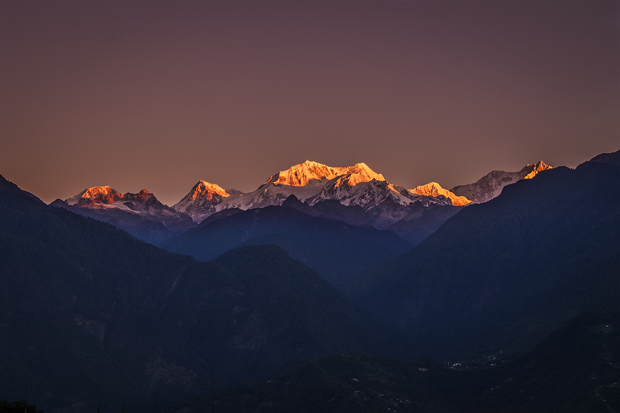
The mountain and why it matters here
Kangchenjunga, at 8,586 m the third highest mountain on Earth, stands on the border of Sikkim and Nepal. Its name is usually translated from Tibetan as the five treasures of the great snow, for its five summits. In Sikkim it is more than a view: Dzö-nga, the mountain deity, is honoured as the guardian of the land, and the Pang Lhabsol festival each August or September gives thanks to it. Sikkimese and many visitors spell it Khangchendzonga; we use both.
West Sikkim, now Gyalshing district, is the closest part of India to the mountain that you can reach by road. From Pelling at about 2,150 m you look straight up the Rathong Chu and Prek Chu valleys to a wall of peaks running from Kokthang and Rathong in the west, through the twin summits of Kabru, to the main massif of Kangchenjunga and on to Pandim in the east. On a clear morning it fills half the northern sky.
When: the months that work
Sikkim's weather follows the monsoon. From June to September, moist air from the Bay of Bengal piles cloud against the Himalaya, and a full view is rare. Once the monsoon withdraws in early October, the air dries and clears, and from mid-October to mid-December you have the best odds of the year. January and February stay clear but bring haze on some days and cold mornings, around 2–5 °C at dawn in Pelling. From late March, warming air lifts dust and haze, and by May clouds build earlier each day.
The table below is our own rule of thumb from years of planning trips, not a weather statistic. Every year differs, so always build in a spare morning.
| Months | Chance of a clear dawn | What to expect |
|---|---|---|
| Mid-Oct to mid-Dec | Best | Crisp, clear mornings; peak season prices; cold nights |
| Late Dec to Feb | Good | Clear but colder, some haze; occasional snow on the ridge |
| Mar to mid-Apr | Fair | Rhododendron season; views early, haze and cloud by mid-morning |
| Late Apr to May | Fair to low | Warm, hazy; clouds build early; best for flowers and birds |
| Jun to Sep | Low | Monsoon cloud; short gaps after rain can be spectacular |
| Early Oct | Good, rising | Post-monsoon clearing; some cloudy days, green hills |
Where: the best viewpoints
Most of the great views in the west are within 5 km of Pelling, which is why the town grew where it did. Here are the places we send people to, in order of how easy they are to reach.
If you are staying in Yuksom, the village itself sits in a basin and only sees parts of the range. Walk up towards Dubdi Monastery or drive back towards Pelling for a wider view. Uttarey and Hee Bermiok see the range at a lower angle across forested ridges, which is lovely in winter but less dramatic than Pelling. Just across the district line in Soreng district, Rinchenpong and the Okhrey–Hilley road also have strong views.
- Upper Pelling and the helipad ground (about 2,150 m): the full range from your hotel balcony or a two-minute walk. Best at sunrise.
- Sanga Choeling ridge and the Chenrezig skywalk (about 2,200 m): a wider, higher outlook above town; 45–60 minutes on foot or a short drive.
- Rabdentse ruins (about 2,000 m): the range framed by the chortens of the old capital; a 1 km forest path from the road gate.
- Pemayangtse Monastery (about 2,085 m): open ground beside the monastery faces the peaks; combine with morning prayers.
- Dzongri Top (about 4,200 m): the close panorama of Kabru, Rathong, Kangchenjunga and Pandim, reached on the Dzongri trek.
- Goecha La viewpoint (about 4,570 m): the south-east face of Kangchenjunga at close range, on the full Goecha La trek.
We turn this into a priced, day-by-day plan for your dates.
Reading the skyline from Pelling
Most people photograph the range without knowing which peak is which. Standing in Upper Pelling and facing north, the snow wall reads roughly left to right as below. Heights are those listed on Wikipedia's Goecha La article; the exact line-up shifts a little depending on where you stand, and some lower peaks hide behind closer ridges.
Kangchenjunga itself is not the tallest-looking peak from every spot, because Kabru is nearer and appears almost as high. Look for the broad, snow-loaded massif slightly right of Kabru, usually the first to catch the light. Hotel staff and drivers in Pelling are generally happy to point the peaks out from the terrace.
- Kokthang, 6,147 m, the lower peak at the western end
- Rathong, 6,679 m, a sharp summit above the Rathong glacier
- Kabru South and Kabru North, 7,318 m and 7,353 m, the long double summit that dominates the left half of the view
- Kangchenjunga, 8,586 m, the broad main massif behind and right of Kabru
- Pandim, 6,691 m, the steep pyramid on the right, above the Prek Chu valley
What time to be outside
Light reaches the summit of Kangchenjunga several minutes before the sun rises over the hills behind Pelling, and the top turns pink, then orange, then white. In late October, sunrise in Pelling is around 5:30 am; in December, closer to 6:15 am. Set an alarm 30 minutes before that, dress warmly and be outside with tea in hand.
On most clear days the view holds until 8 or 9 am, then cloud starts to rise from the valleys. Late afternoons in November can also be clear, and the range turns gold at sunset, around 4:45–5 pm. If the dawn is cloudy, do not give up: cloud often breaks for 15–20 minutes later in the morning.
How many nights to give yourself
One night in Pelling gives you one chance. Two nights gives you two mornings, and in October to December that usually means at least one good view. Three nights is what we recommend for photographers and anyone travelling outside the best window. For a honeymoon or a special trip, ask for a north-facing room with a balcony; it is worth the ₹500–1,500 extra a night in a mid-range hotel.
If your trip is short, put Pelling in the middle of it, not the last night, so you still have a morning in hand if the first is cloudy.
Photographing the range
A phone gets good results if you tap to expose for the snow, not the dark hills, and use the 2x or 3x lens to fill the frame. With a camera, a 70–300 mm lens lets you isolate the summits; a wide lens works when you include prayer flags, the Rabdentse chortens or the Pemayangtse roofs in front. Bring a small tripod for the low light before sunrise and spare batteries, which drain fast in the cold.
Please be respectful at monasteries and the Rabdentse ruins: do not climb on walls or chortens for a better angle, ask before photographing monks, and fly a drone only with the required permissions, which are rarely granted near monasteries and border areas.
If the clouds win
Some trips get no view at all, especially in spring and the monsoon. Plan the rest of the day so it still feels worthwhile: the monasteries and Rabdentse are rewarding in any weather, Khecheopalri Lake is at its most atmospheric in mist, and Kanchenjunga Falls and Rimbi waterfall are fullest after rain. In the monsoon, keep an eye on the sky after heavy showers, because the cleanest views of the year sometimes come in a sudden gap. Check current road status before driving out early in the rains.
Rules, fees, fares and road status change often. Check current status before you travel.


